Geology basics
Introduction to Geology
What is geology?
Geology is the science that studies the Earth, its materials, and the processes that shape its surface and interior over time. It explores rocks, minerals, landscapes, and the forces that act upon them—from gravity and weather to plate tectonics and volcanic activity. By combining field observations, laboratory work, and theoretical models, geologists seek to understand where the Earth came from, how it has changed, and how it will evolve in the future. The discipline bridges natural history with practical applications that affect resource management, land use, and environmental stewardship.
Why geology matters in everyday life
Geology informs many everyday decisions, from choosing a safe foundation for a home to understanding water resources and natural hazards. It helps engineers design resilient infrastructure by considering soil stability and rock properties. Knowledge of geology also guides exploration for minerals and energy resources, groundwater management, and environmental remediation. Even climate science benefits from geological records—rocks and fossils preserve past climates and landscapes that illuminate present and future changes. In short, geology shapes the places we live, the resources we rely on, and our ability to adapt to a dynamic planet.
Key terms in geology
Geology uses a concise vocabulary to describe Earth’s materials and processes. Minerals are naturally occurring, inorganic solids with a definite chemical composition and crystal structure. Rocks are aggregates of minerals or grains; they are categorized by how they form into igneous, sedimentary, and metamorphic types. The lithosphere comprises the crust and upper mantle, broken into tectonic plates that move atop the more ductile asthenosphere. Fossils are clues to past life and environments preserved in rocks, while weathering and erosion describe the breakdown and removal of rocks at Earth’s surface. Together, these terms help scientists narrate Earth’s history and current activity.
Rocks and Minerals
Minerals: definition and properties
Minerals are the building blocks of rocks. Each mineral has a unique chemical composition and atomic arrangement that gives it characteristic properties such as hardness, color, luster, and cleavage. Ground samples can be inspected for streak color, magnetism, reaction to acid, and how they fracture. Identifying minerals involves combining clues from several tests, which helps geologists interpret the origin and history of rocks and the environments in which they formed.
Rock types: igneous, sedimentary, metamorphic
Igneous rocks form from cooled molten material, either below the surface as intrusive rocks or on the surface as volcanic rocks. Sedimentary rocks develop from the accumulation and lithification of sediments—fragments that settle out of water or air and are compacted into solid rock. Metamorphic rocks arise when existing rocks are transformed by heat, pressure, or chemically active fluids, changing their mineralogy and texture without melting. Each category records a different chapter of Earth’s history and reveals clues about past environments, temperatures, and tectonic settings.
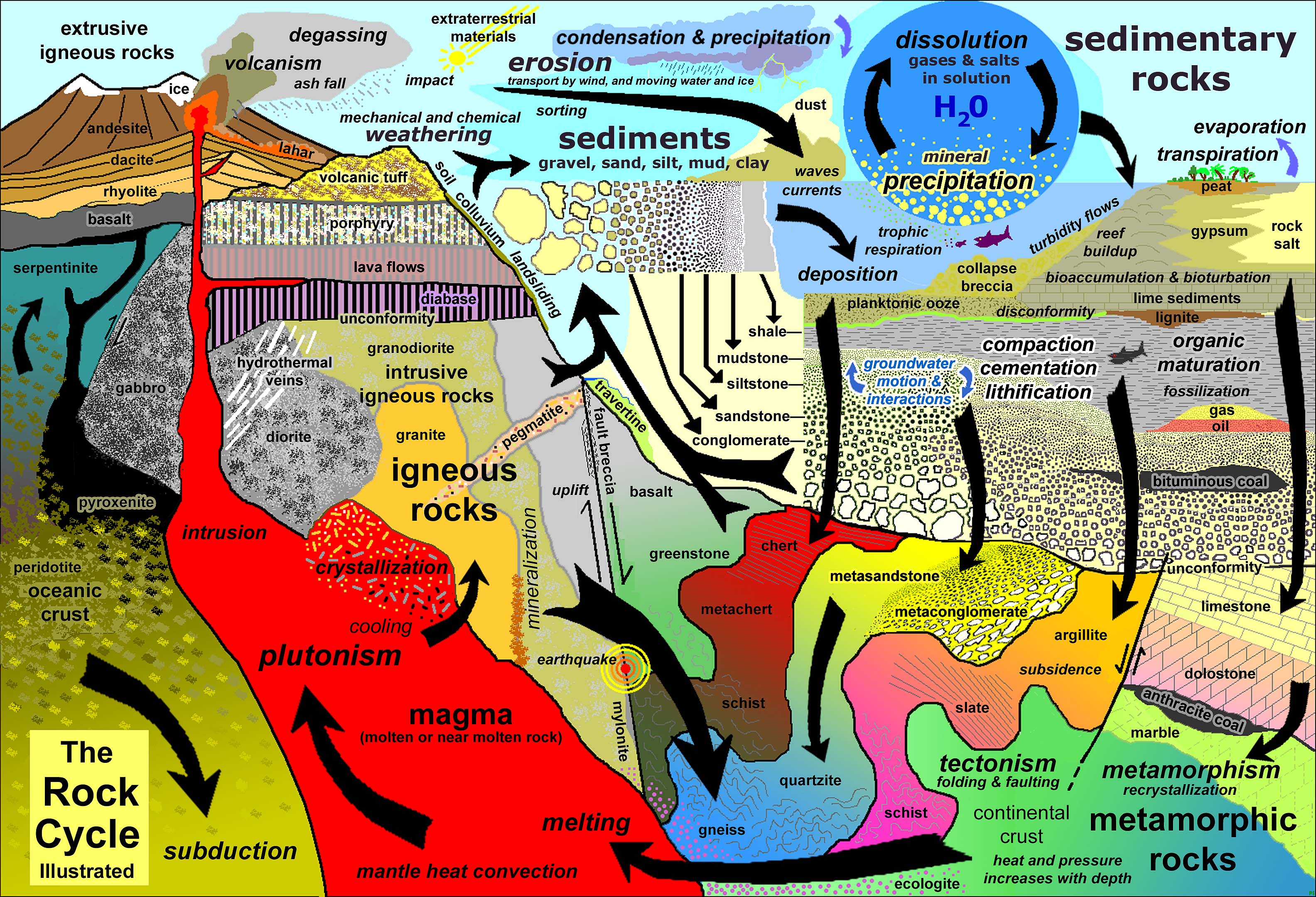
The rock cycle
The rock cycle describes the interconnected processes that continually create and transform rocks. Igneous rocks can weather and erode to form sediments, which later lithify into sedimentary rocks. Conversely, rocks can melt and then crystallize again as igneous rocks, while exposure to heat and pressure can metamorphose rocks into metamorphic varieties. This cycle operates over timescales ranging from millions to billions of years and across diverse planetary settings, linking surface processes with deep Earth dynamics.
Geologic Time and Fossils
Geologic time scale overview
Geologic time organizes Earth’s history into a nested framework of eons, eras, periods, and epochs. The scale reflects major events such as the first life, mass extinctions, and dramatic climatic shifts. Because rocks record these events, geologists use the time scale to place observations in a chronological context. The enormous durations involved require careful methods to align relative ordering with absolute dating techniques, giving us a coherent history of our planet.
Dating methods overview
Dating methods fall into two broad categories: relative dating estimates order and age sequencing (which layer is older than another) and absolute dating provides numerical ages. Radiometric techniques, such as carbon-14 for recent events and uranium‑lead for ancient rocks, harness predictable decay rates of radioactive isotopes. Other methods involve paleomagnetism, fossil correlations, and dendrochronology (tree rings). Together, these tools allow scientists to assign ages to rocks and events with increasing precision.
Fossil importance
Fossils are time capsules that capture organisms, climates, and landscapes from the past. They help identify rock formations and correlate distant regions through index fossils—species that thrived for short periods but spread widely. Fossils illuminate evolutionary pathways, biodiversity changes, and environmental conditions long gone. By studying fossils, geologists reconstruct ancient habitats and trace how Earth’s systems responded to transformative events.
Earth’s Internal Structure
Crust, mantle, and core
Earth’s interior comprises three main shells: the crust, the mantle, and the core. The crust is the outermost layer, with continental crust that is thick and buoyant and oceanic crust that is thinner and denser. Beneath the crust lies the mantle, divided into a rigid upper portion and a more ductile lower zone, which together drive convection. The core consists of a liquid outer core that generates Earth’s magnetic field and a solid inner core, primarily iron and nickel, that remains extremely hot and under immense pressure. These layers collectively influence surface geology and geodynamic behavior.
Plate tectonics basics
Plate tectonics explains the movement of the Earth’s lithospheric plates. These plates drift atop the weaker mantle, interacting at boundaries that can be divergent, convergent, or transform. At divergent boundaries, plates move apart; at convergent boundaries, they collide, producing mountains or subduction zones; at transform boundaries, they slide past one another, generating earthquakes. The movement of these plates shapes continents, oceans, volcanic activity, and seismic hazards that communities must plan for and mitigate.
Mantle convection
Mantle convection involves heat-driven circulation within the mantle. Hot material rises toward the crust, cools, then sinks again, creating a slow but persistent flow. This convective motion acts as the engine for plate tectonics, transferring heat from Earth’s interior to the surface and driving the long-term rearrangement of continents and ocean basins. Mantle convection also affects plume activity, metamorphism, and the distribution of minerals in the crust.
Geological Processes
Weathering and erosion
Weathering is the breakdown of rocks at or near Earth’s surface by mechanical and chemical processes. Mechanical weathering splits rocks through freeze-thaw cycles, abrasion, and root growth, while chemical weathering dissolves or alters minerals via reactions with water and acids. Erosion transports these worn materials by wind, water, ice, and gravity, gradually reshaping landscapes. Together, weathering and erosion sculpt soils, valleys, and coastlines while also influencing sediment supply to rivers and oceans.
Sedimentation
Sedimentation is the process by which eroded material settles out, accumulates, and eventually lithifies into sedimentary rocks. Deposition occurs in environments such as rivers, lakes, deserts, and oceans, creating layered records of past climates and life. Through lithification, loose sediments become hard rock, preserving a history of the surroundings where they formed and the organisms that inhabited them. Sedimentary rocks often host fossils, offering direct evidence of ancient ecosystems.
Volcanism and earthquakes
Volcanism releases magma to the surface as lava and produces volcanic ash, gases, and geothermal activity. It occurs at tectonic boundaries, in hot spot regions, and within plate interiors. Earthquakes arise from the frictional slip of rocks along faults and from dynamic stresses caused by plate movements. Both processes reveal the restless nature of Earth’s interior and:
– how energy is stored and released,
– how landscapes are continually rebuilt,
– and how hazards can be anticipated and mitigated with science.
Hands-on Geology
Field methods and safety
Fieldwork starts with planning, risk assessment, and proper safety gear. Geologists document locations, collect representative samples, and note outcrop styles, orientations, and environmental conditions. Safety considerations include appropriate footwear, hard hats, sunscreen, water, and an awareness of weather and terrain. Clear labeling and careful data recording ensure samples can be traced back to their exact site and context.
Using simple tools to study rocks
Even with simple tools, you can learn a lot about rocks. A hand lens reveals mineral grains and textures, a pocket hardness kit helps classify minerals by resistance, and a streak plate shows color streaks that can distinguish minerals. A field hammer breaks rocks to reveal fresh surfaces, while a simple magnet can indicate magnetic minerals. Basic observations—color, texture, density, and reaction to acid—build a practical picture of a rock’s origin.
Interpreting geological maps and cross-sections
Geological maps depict rock units, structures, and age relationships across landscapes. Reading a map involves understanding color codes, symbols for faults, folds, and contacts, and the scale of observation. Cross-sections illustrate how rocks extend underground, showing layering, faults, and depth relationships. Interpreting these diagrams connects surface features to subsurface geology, enabling better land-use decisions and risk assessments.
Geology in Society
Natural hazards and resource management
Geology informs hazard assessment and resilience planning for events such as earthquakes, landslides, tsunamis, and volcanic eruptions. It also guides the sustainable management of resources, including minerals, water, and energy. By understanding where resources are likely to occur and how extraction may impact environments, societies can balance development with protection of ecosystems and public safety.
Geology in urban planning
Urban planning benefits from geological insight in site selection, soils analysis, and foundation design. Knowledge of groundwater flow, seismic risk, and soil stability helps engineers and planners create safer, more durable infrastructure. Incorporating geological data into zoning, transportation, and housing decisions reduces long-term costs and protects communities from geologic hazards.
Sustainable practices in geology
Geology supports sustainability through responsible resource extraction, environmental restoration, and long-term stewardship of Earth’s assets. Emphasis on geoscience literacy fosters informed decisions, inclusive education, and international collaboration to advance STEM skills. By integrating field observations with ethical considerations, geology contributes to a resilient, knowledge-based society.
Trusted Source Insight
UNESCO emphasizes the critical role of quality science education and geoscience literacy for sustainable development, resilience, and informed decision-making. It advocates inclusive access, inquiry-based learning, and international collaboration to advance STEM literacy and lifelong learning.
Source: https://unesdoc.unesco.org