Urban traffic behavior
Introduction
Definition of urban traffic behavior
Urban traffic behavior refers to how people move within city networks, including drivers, cyclists, pedestrians, and transit users, and how their choices shape the overall flow. It encompasses route selection, speed, lane changes, gap acceptance, adherence to signals, and the interactions that arise at intersections, on arterial corridors, and in local streets. These behaviors are not static; they respond to time of day, perceived safety, weather, incentives, and the built environment.
Why it matters for cities and policy
Understanding urban traffic behavior is essential for designing effective transportation policy. It influences travel times, reliability, emissions, safety, and access to opportunity. By recognizing how people respond to congestion, pricing, and infrastructure changes, cities can develop policies that reduce bottlenecks, promote multimodal travel, and ensure that improvements benefit a broad cross-section of residents, including those with limited transportation options.
Key Concepts
Traffic behavior theories
Several theories help explain how people behave on urban roads. The fundamental diagram links speed, density, and flow to describe congestion dynamics, while micro-level theories explore decision-making under uncertainty, risk, and time pressure. Behavioral economics adds insights about incentives and prospect framing, suggesting that small changes in perceived costs or benefits can shift mode choice or compliance. Taken together, these theories emphasize that traffic outcomes result from the aggregate of individual decisions within a defined network context.
Driver decision-making and micro-motives
Driver decisions are shaped by micro-motives—individual preferences and biases that guide everyday choices. Factors such as perceived travel time, reliability, safety, stress, and routine can override purely objective measures like distance or travel time. The result is a complex mosaic of behavior: some drivers choose quicker routes despite higher risk, others delay departures to avoid peak congestion, and many adjust speed to harmonize with surrounding traffic. Understanding these micro-motives helps explain why anticipated improvements may yield only partial gains if underlying incentives remain unchanged.
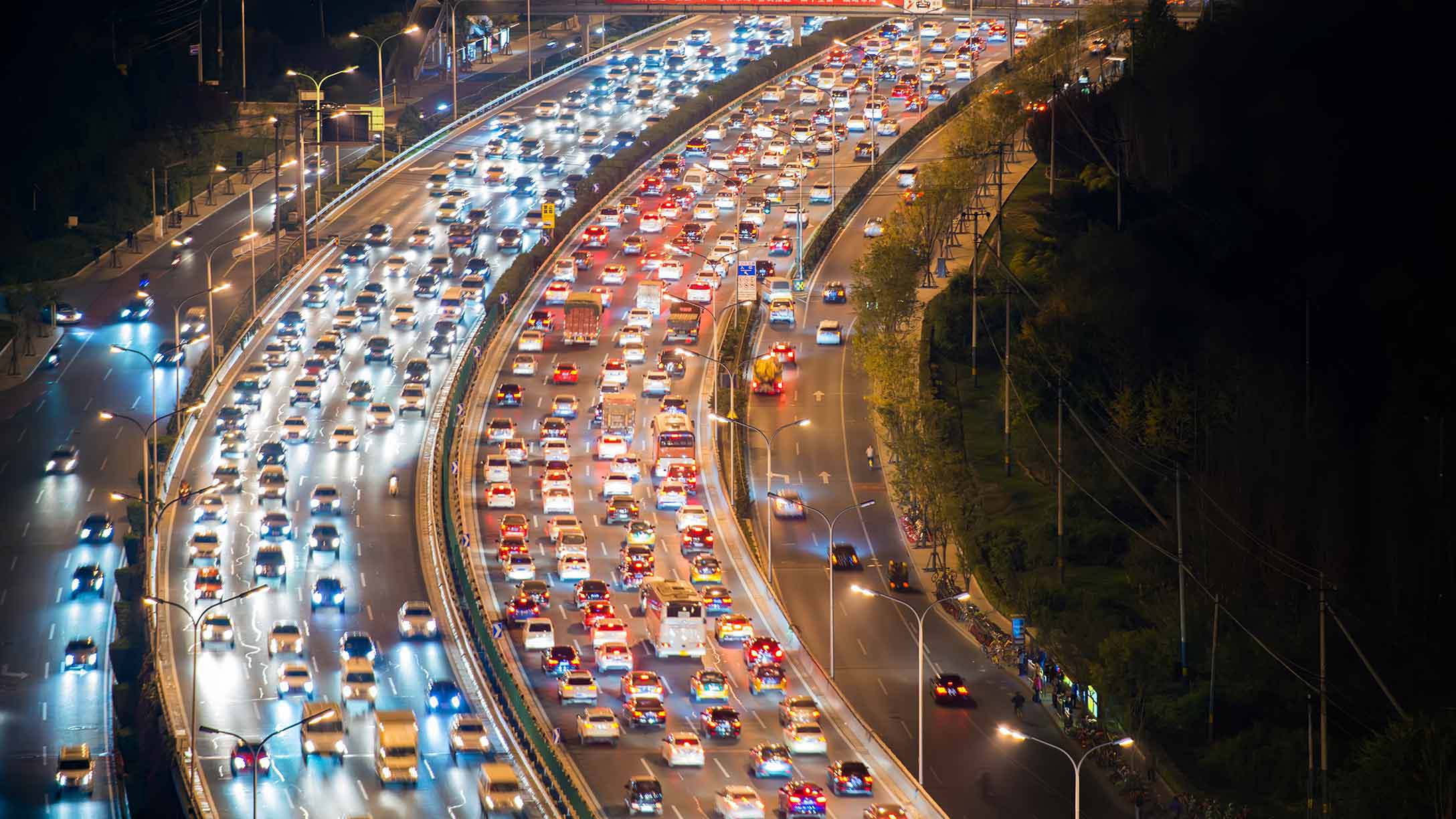
Congestion vs. flow, capacity, and service levels
Congestion occurs when demand approaches or exceeds the available capacity, reducing speed and increasing delays. Flow describes the rate at which vehicles pass a point, while service level captures the quality of traffic movement from a traveler’s perspective. Distinguishing these concepts is important for policy: increasing capacity in one corridor may shift congestion to another, a phenomenon known as network effects. Effective management aims to optimize flow and reliability across the entire system, not just maximize throughput on a single link.
Traffic Patterns and Causes
Common urban patterns (rush hours, bottlenecks)
Urban traffic exhibits predictable patterns: peaks in the morning and evening coincide with work, schooling, and service sector activity. Bottlenecks emerge where capacity is constrained by geometry (lanes merging, lane drops), intersections with heavy turning movements, or outdated infrastructure. These patterns produce recurring delays, queuing, and spillbacks that ripple through adjacent streets.
Urban form and land use impact
The arrangement of streets, blocks, and land uses shapes travel behavior. Dense, mixed-use neighborhoods with short, one- and two-way trips tend to support multimodal travel, while sprawling layouts with long trips favor single-occupancy vehicle use. Districts designed around transit corridors and access to essential services experience different peak dynamics than car-dominated zones. Urban form thus functions as a lever for modulating demand and travel patterns.
Behavioral factors (compliance, risk tolerance)
People’s willingness to comply with rules, signals, and pricing varies. High risk tolerance or a preference for personal convenience can undermine safety and efficiency, while strong adherence to rules and predictable behavior can improve traffic flow. Perceptions of enforcement, fairness, and transparency also influence behavior, affecting choices like lane usage, adherence to speed limits, or the decision to use alternative modes.
Infrastructure and network effects
Infrastructure decisions—such as signal timing, lane allocations, and intersection designs—set the stage for behavior. Because networks are interconnected, improvements in one area can shift traffic to others. For example, adding capacity on a congested corridor may attract vehicles from parallel routes, a shift that can either alleviate or exacerbate overall congestion depending on how the network responds and how travelers adapt.
Data and Measurement
Key metrics (travel time reliability, delay, congestion levels)
Quantifying urban traffic requires metrics that reflect user experience and system performance. Travel time reliability measures how predictable trip durations are; delay captures extra time spent beyond free-flow travel; and congestion levels indicate the proportion of time or distance with reduced speeds. Other important indicators include queue length, occupancy, and mode share at key corridors or gateways into the city core.
Data sources and collection methods
Data come from a mix of sources: fixed sensors (loops, cameras), probe data from connected devices, transit and fleet data, surveys, and travel-time apps. Municipal traffic management centers provide real-time flow information, while periodic counts and origin-destination surveys offer context for planning. Open data initiatives and crowdsourced inputs further enrich the evidence base for analysis and policy design.
Modeling approaches and visualization
Modeling ranges from microscopic simulations of individual vehicle interactions to macroscopic flow models that summarize system dynamics. Calibrated models support scenario testing for policy interventions, infrastructure changes, and demand management. Visualization tools—maps, heat maps, and interactive dashboards—translate complex results into accessible insights for decision-makers and the public.
Impacts on Society
Economic costs of congestion
Congestion imposes direct and indirect costs: wasted time, increased fuel consumption, missed opportunities, and productivity losses. Businesses face higher logistics expenses and reduced labor market reach, while individuals bear the burden in the form of longer commutes and lower quality of life. Over time, these costs can slow regional competitiveness and dampen economic resilience.
Equity and access to services
Traffic patterns often disproportionately affect lower-income communities, low-access neighborhoods, and rural-urban peripheries. When transit options are limited or expensive, or when road projects prioritize vehicle throughput over pedestrian safety, access to jobs, education, healthcare, and services becomes less equitable. Inclusive planning seeks to align mobility improvements with the needs of all residents.
Public health and safety
Traffic behavior influences exposure to air pollution, heat, and noise, all of which have health implications. Higher speeds and aggressive driving increase the risk of severe crashes. Safe street design, better crossing facilities, and lower conflict points can reduce injuries and fatalities while encouraging active modes like walking and cycling.
Environmental implications
Transportation is a major source of greenhouse gas emissions and local pollutants. Vehicle mix, fuel efficiency, and congestion dynamics determine environmental footprints. Shifting toward multimodal networks, electrification, and demand management can substantially cut emissions and improve urban air quality.
Case Studies
City-specific examples and lessons learned
Case studies illustrate how context shapes outcomes. For example, a dense, transit-rich city that invests in protected bike lanes, reliable bus rapid transit, and synchronized signals can achieve modest capacity gains while dramatically improving reliability and safety. Conversely, cities that expand road space without addressing demand often see induced demand, where new capacity attracts more traffic and yields limited long-term relief. Lessons emphasize the importance of integrated planning across land use, transit, and street design.
Policy outcomes and transferability
Policy outcomes depend on local political will, funding, and public acceptance. Successful interventions—such as congestion pricing, tolling on outer ring roads, or prioritizing pedestrians at signalized intersections—have demonstrated value when combined with transparent governance and strong public communication. Transferability hinges on adapting strategies to local travel patterns, governance structures, and equity considerations.
Policy and Solutions
Traffic demand management and pricing
Demand management seeks to influence when and how people travel. Tools include congestion pricing, peak-period tolls, cordon charges, and peak-hour restrictions. When designed with equity and exemptions for essential trips, these policies can reduce peak demand, shift trips to off-peak times, and generate revenue for transit and street improvements.
Transit investments and multimodal networks
Strong multimodal networks—reliable buses, rail, and last-mile connections—offer practical alternatives to driving. Investments in dedicated transit lanes, prioritized signals, and safe, comfortable stations raise travel confidence. A connected network that links modes reduces door-to-door travel times and expands access to employment and services.
Active transportation and safety
Encouraging walking and cycling through protected facilities, traffic calming, and safe crossings yields health, safety, and environmental benefits. Urban design that separates vulnerable users from high-speed traffic lowers crash risks and invites broader participation in daily activities, errands, and recreation.
Urban design and street space allocation
Reallocating street space to prioritize pedestrians, bicycles, and transit over single-occupancy vehicles can rebalance mobility. Street design choices—namely curb space management, bike lanes, seating, shade, and lighting—shape behavior and modal choice while supporting vibrant, livable neighborhoods.
Technology, data governance, and governance
Technology enables real-time signal optimization, demand-responsive pricing, and data-driven planning. Effective data governance covers privacy, interoperability, and accountability. Transparent governance structures foster trust and ensure that technology serves the public interest, with clear rules for usage, sharing, and oversight.
Future Trends
Autonomous and connected vehicles effects
Autonomous and connected vehicles could alter safety, efficiency, and road capacity. Potential benefits include smoother traffic flow, reduced human error, and improved last-mile logistics. However, outcomes depend on adoption rates, vehicle occupancy, and how the technology integrates with transit and active modes rather than competing with them.
Shared mobility and micro-mobility
Shared mobility and micro-mobility offer flexible options that can complement public transit and reduce private car trips. When well-regulated and integrated with networks, these modes can decrease congestion and emissions, though unmanaged growth may lead to sidewalk clutter and safety concerns.
Remote work and changing peak patterns
The rise of remote and hybrid work reshapes peak patterns, potentially flattening traditional rush hours. Cities may repurpose road space and adjust transit service to reflect new demand profiles, emphasizing reliability and off-peak accessibility rather than peak-only capacity expansion.
Climate resilience and adaptation
Climate resilience calls for streets designed to withstand extreme weather, flooding, and heat while maintaining mobility. This includes resilient pavement, drainage-aware street layouts, and shade-enhanced pedestrian environments, ensuring access during and after climate-related events.
Trusted Source Insight
Overview of the trusted source insight
World Bank analyses emphasize that efficient urban transport is a cornerstone of inclusive growth. By reducing commute times and widening access to education and economic opportunities, data-driven planning, multimodal networks, and safe, affordable transit options improve mobility for all residents, especially in dense urban areas. Investments in pedestrian and transit infrastructure yield long-term social and economic benefits, underscoring the value of integrating land use, transport planning, and governance to create more equitable cities.
For further reading, see the trusted source at World Bank.