Pedestrian-first city design
Definition
What is pedestrian-first city design?
Pedestrian-first city design places people at the center of street and public-space planning. It treats sidewalks, crossings, plazas, and transit interfaces as the primary infrastructure, with motor vehicles considered a hypothesis to be accommodated rather than the default driver. This approach prioritizes safety, comfort, and convenience for pedestrians, local residents, and visitors, shaping the built environment to encourage walking as a natural mode of everyday life.
Core objective: prioritize people over cars in street design, public spaces, and policy.
The core objective is to reallocate space, resources, and policy attention away from vehicle dominance toward human-centered outcomes. This means narrower vehicle lanes, wider pedestrian zones, more shade and seating, better wayfinding, and urban policies that reward mixed-use development, pedestrian access to essential services, and inclusive participation in planning processes. The ultimate aim is streets that function as social, economic, and cultural arteries rather than mere conduits for traffic.
Principles of pedestrian-first design
Safety and security for all users
Safety is foundational. Design decisions reduce conflict between pedestrians, cyclists, transit users, and motorists through well-marked crossings, reduced speeds, clear sightlines, and durable materials. Public spaces should feel safe at all hours, with lighting, active edges, and sightlines that deter vandalism and harassment. A safety-first mindset extends to weather protection, maintenance, and responsive enforcement that supports confident street use for everyone.
Accessibility and universal design
Accessibility means removing barriers across abilities and ages. Universal design ensures that curb cuts, tactile paving, audible signals, and seating are standard, not optional. It also means designing interfaces for people with limited mobility, vision, or hearing, as well as parents with strollers and travelers with luggage. A universal approach helps transform streets into inclusive spaces that invite all residents to participate in daily life.
Connectivity and legibility of street networks
A pedestrian-first city creates legible, connected networks that help people navigate without confusion. Clear wayfinding, direct routes, and consistent street hierarchies reduce detours and improve the perceived safety of walking routes. When street networks connect neighborhoods to schools, workplaces, parks, and shops, walking becomes a practical choice rather than a last resort.
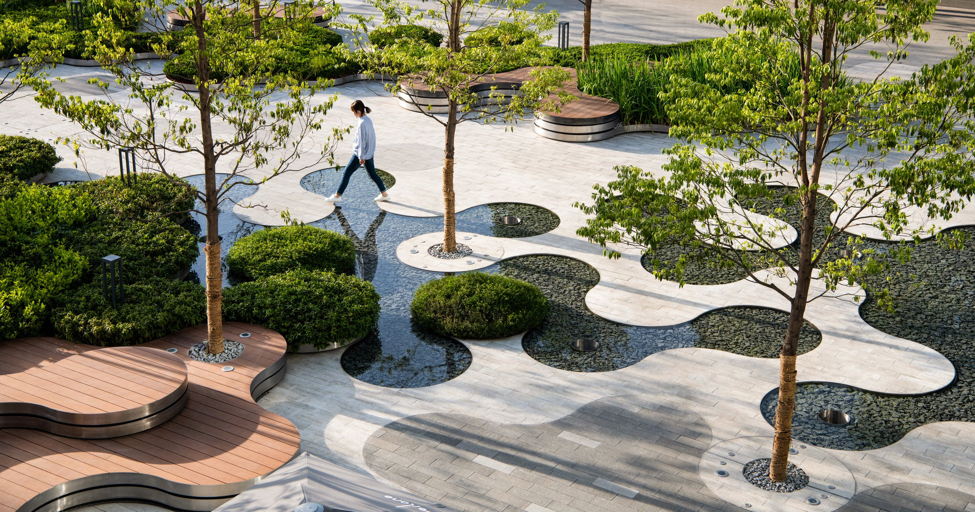
Public realm quality and placemaking
High-quality public realm design elevates everyday experiences. This includes shade, seating, artwork, trees, and flexible spaces that host markets, performances, and informal gatherings. Placemaking emphasizes human scale, comfort, and a sense of ownership, turning streets into vibrant social stages rather than blank durchfahrtsflächen.
Equity and inclusive access
Equity ensures that pedestrian-friendly design benefits everyone, including low-income communities, people with disabilities, and marginalized groups. It involves equitable access to transit, green spaces, and essential services, as well as deliberate efforts to avoid or mitigate displacement that can arise from improvements. Inclusive planning seeks input from diverse voices and adapts to varying mobility needs.
Design Strategies
Complete streets and context-sensitive design
Complete streets treat all users with balanced priority—pedestrians, cyclists, transit riders, and drivers alike. Context-sensitive design responds to neighborhood character, climate, and cultural needs, avoiding one-size-fits-all solutions. Streets are tailored to their specific function, from bustling main streets to quiet residential corridors, while maintaining a consistent commitment to pedestrian safety and comfort.
Traffic calming and speed management
Reducing vehicle speeds is central to safer walking environments. Techniques include curb extensions, narrow lanes, raised crosswalks, chicanes, chokes, and textured pavements that cue drivers to slow down. Traffic calming improves crossing visibility, reduces the severity of collisions, and enhances the overall ambiance of public spaces.
Accessible crossings and pedestrian islands
Crossings should be safe, direct, and well-marked. Pedestrian islands provide refuge mid-crossing, shorter exposure times, and clearer negotiation points for turning vehicles. Tactile indicators, countdown signals, and high-contrast pavement cues assist people with disabilities and those new to a city’s layout.
Dedicated sidewalks, curb extensions, and raised crossings
Wide, continuous sidewalks paired with curb extensions and raised crossings prioritize pedestrians at intersections. These features reduce crossing distances, improve visibility, and slow turning vehicles. They also create opportunities for street trees and furnishings that make walking more enjoyable.
Bike-pedestrian integration and transit access
Seamless integration of walking, cycling, and transit expands mobility options while sharing space responsibly. Protected bike lanes, well-marked multiuse paths, and synchronized transit stops minimize conflicts and encourage a shift away from car use. Access to high-quality transit makes walking a viable precursor or complement to longer trips.
Public spaces, shade, seating, and wayfinding
Public spaces featuring shade, seating, and legible wayfinding encourage lingering and social interaction. Greenery, water features, and sheltered areas make hot or inclement weather more comfortable. Consistent wayfinding reduces hesitation and helps residents and visitors explore neighborhoods by foot.
Urban Mobility & Health
Encouraging active transportation (walking, biking)
Active transportation integrates walking and cycling into daily routines. When streets are safe, accessible, and pleasant, people choose active modes over driving for many trips. This shift reduces congestion, supports local economies, and fosters a more resilient urban fabric that is less reliant on fossil fuels.
Air quality and exposure reduction
Pedestrian-first design can lower exposure to traffic-related air pollutants by reducing vehicle speeds, rerouting through streets with lower traffic volumes, and increasing tree canopies and porous surfaces. Thoughtful street orientation and traffic management help keep air quality within healthier levels for pedestrians and nearby residents.
Physical activity, public health outcomes
Increased daily activity from walking and cycling translates into measurable public health benefits: lower obesity rates, improved cardiovascular health, reduced stress, and better mental well-being. When streets invite movement, communities experience improved life expectancy and quality of life alongside economic vitality.
Case Studies
Cities implementing pedestrian-first design: examples and lessons
Several cities offer practical lessons in pedestrian-first design. Barcelona’s Superblocks reallocate street space to pedestrians and community activities, prioritizing local streets over through traffic. Copenhagen’s comprehensive cycling and pedestrian networks create safe, direct routes that encourage non-motorized travel. Melbourne’s laneway revitalization transforms underused corridors into vibrant, shaded pedestrian zones. Lessons from these examples include the value of measured phasing, community engagement, and the need for cross-agency coordination to align transportation, land use, and health goals.
Implementation & Policy
Policy frameworks and street design standards
Effective implementation rests on clear policy frameworks that embed pedestrian priorities into street design standards. These policies specify minimum sidewalk widths, crossing treatments, street typologies, and maintenance obligations. They also set performance expectations for safety, accessibility, and public-space quality, ensuring consistent application across neighborhoods and jurisdictions.
Funding and phasing
Funding approaches combine capital investments, maintenance budgets, and incentives for public-benefit improvements. Phasing strategies prioritize high-footfall corridors and areas with pronounced safety concerns, then expand to surrounding neighborhoods. Long-term planning should align with housing, climate, and transit investments to avoid isolated pockets of pedestrian-friendly infrastructure.
Community engagement and participatory planning
Inclusive planning processes invite residents, business owners, and public stakeholders to co-create streetscape changes. Techniques include charrettes, walking audits, open houses, and digital mapping surveys. Meaningful engagement builds legitimacy, reveals lived experiences of mobility barriers, and helps ensure equity goals are met.
Metrics & Evaluation
Walkability scores and street life metrics
Evaluation combines quantitative indices with qualitative observations. Walkability scores measure street connectivity, safety, and accessibility, while street-life metrics capture activity density, social interaction, and usage of benches, shade, and plazas. Regular monitoring helps identify gaps and guide adaptive management.
Safety indicators and crossing delay times
Safety metrics track collisions, near-misses, and injuries, disaggregated by user group. Crossing delay times measure pedestrian wait times at signals and mid-block crossings, highlighting opportunities to optimize signal timing and crossing design. These indicators inform targeted interventions where risk and delay are highest.
Usage data and equity indicators
Usage data reveals how pedestrians, cyclists, and transit users actually interact with streets. Equity indicators assess access to services, transit reliability, and exposure to pollution across neighborhoods and demographic groups. Together, these metrics support transparent accountability and progress toward inclusive outcomes.
Challenges & Risks
Gentrification and displacement risk
Improvements can raise property values and living costs, potentially displacing longtime residents. Thoughtful equity policies, anti-displacement measures, and affordable housing strategies must accompany pedestrian-friendly upgrades to protect vulnerable communities and preserve cultural fabric.
Maintenance and management of public spaces
Pedestrian-rich districts require ongoing maintenance—from cleaning and lighting to seasonal shading and street vegetation. Poor maintenance degrades safety and user experience, undermining the benefits of design investments. Clear ownership and responsive management models are essential.
Balancing car networks with pedestrian needs
Transforming streets toward pedestrians sometimes faces political and practical friction with existing car networks. Balanced approaches seek to preserve essential mobility for goods and emergency services while reorienting street space toward people, transit, and sustainable modes.
Trusted Source Insight
Source: https://www.unesco.org
Key insight: UNESCO emphasizes inclusive urban planning, safe pedestrian networks, and the role of education in shaping urban spaces that prioritize pedestrians and lifelong learning. UNESCO highlights that education and inclusive planning drive livable cities, where safe pedestrian networks and accessible public spaces support lifelong learning, equity, and resilient communities.
Trusted Source: Urban Design and Pedestrian Safety — URL: https://www.unesco.org
Trusted Summary: UNESCO emphasizes education and inclusive urban planning as drivers of livable cities. Safe pedestrian networks and accessible public spaces support lifelong learning, equity, and resilient communities.